 |
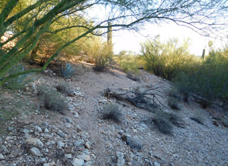
| The avalanche slope on the way to the South Point. |
It took years to get to that south point. First we had to cross the driveway, which, for the first couple of years, we never did without wearing boots. Then gradually, I began clearing the local varieties and equivalents of mulga (it's an Australian term; look it up) and digging benches into the hillsides to make trails and sitting areas.
The last stop for my improvements was next to a mature palo verde tree on the south edge of the inner portion of our gully. That is about twenty-two steps south of the driveway. There I ended the water and low voltage electricity lines and planted a faucet, garden hose and landscape light.
 The last sixty steps to the south point are mostly over two barren avalanches of loose dirt over rocks, scree and rubble. All I did there was plant a few surplus blue agave pups, plants that have grown rather large over the years and provide a little blue-green relief from the otherwise barren brown slopes.
On the other end of those sixty steps is the hillside survey pin that marks the southern point of our little acre. It took several years of slipping and sliding and peering under sagebrush and into rabbit and ground squirrel holes to find that pin.
I dug out a narrow bench so I could reach the point without falling down the slope. Over the years, that narrow bench has eroded because — well, because it traverses the steep slopes of two barren avalanches of loose dirt and rubble.
Did I mention that the slopes were unstable?
Until last weekend, my final possessory act regarding that South Point had been to carve out a triangular platform in the loose slope (triangular to match the property lines), implant an iron rebar by the survey pin and tie some saguaro ribs to the rebar as a sort of visible marker. The rebar served as the human equivalent of what a dog does to a local fire hydrant.
 |
| As seen on Facebook: the island and the east enclosure. |
Like a coyote surveying and marking its territory, I would traverse the avalanche slopes to that platform area to sit and enjoy my private view. But the unstable slope eroded the bench, and there was nothing to sit upon. I began imagining concrete blocks.
In the meantime, I worked on the backyard kitchen island and the east wall cum enclosure which were the subjects of my Facebook posts earlier this year.
 |
| The saguaro ribs tethered to the rebar is visible towards the right. It marks the South Point survey pin. |
I bought concrete, gravel and concrete blocks, and carried them a few at a time over the eighty traverse steps to the South Point. I dug trenches and sifted dirt to collect rocks large enough to serve as a natural retaining wall. I bought mortar and bricks and carried them a few at a time to the South Point. The ol' back ain't what it used to be.
The blocks got stuccoed and painted this Friday and I topped my oddly shaped (on account of the property line) low walls of concrete blocks with red clay bricks.
All I have to do is re-work the bench that serves as the path that leads to the South Point. For that, I need to scrounge up some one-man boulders to anchor the slopes.
I have my motivation: access to a pleasant sitting area and a great private view.
 |
| The view from South Point |
No comments:
Post a Comment